Monday, July 30, 2012

That Crow on Horton Plains will stay there much longer……….

Ever since the Horton Plains was declared a National Park in 1988; so was the influx of  busloads of visitors to view the famous escarpment named the World’s  End. Its a pity that most visitors only come here to view the precipices and the Baker’s Fall. They seem to be ignorant of the fauna and flora that is unique to the plains and its pre-history.

Panorama 10
People come here  in buses, vans, cars

Be that as may ……..with the human visitor there came on the plains the Jungle Crow that is known to  keep company with humans. The crow is also known as an indicator species on the changing environment. A close ally with trash and garbage . 

DSC_0329 WE copy
Little World's End Escarpment

Food and water was permitted on the 9 km trek to the World’s End and back for the weary traveller who was hungry and thirsty. Part of this  food was left on the plains as waste on which the crows feasted.
Today the authorities are more concerned and they do not allow food in wrappers in the park and much of the unconsumed food come back in the backpacks the visitor carries along.  Thus the crow is not directly dependent on  the waste food.

It has now adapted a new survival strategy………………..

Animals are said to make strange and odd partnerships. These strange relationships are needed for their safety and to overcome the struggle for existence. They are know as Symbiotic Relationships in the study of Field Biology. One animal helping the other to meets its needs. 

DSC_0339 (2) crop copy
A Symbiotic Relationship
DSC_0341 crop copy
Looking for the tick
The Jungle Crow that came on the plains has now made a symbiotic relationship with the Sambar Deer. It is interesting to note that the tick on the Sambar Deer that guzzles its blood is also a symbiotic relation, but the ticks do not help their host; instead they  pass germs that cause disease.

On the other hand the symbiotic relationship of the crow with the sambar deer  is a favourable one as the crow consumes the disease causing tick. 

DSC_0346 blog copyDSC_0351 (2) blog copy

 The crow on the Plains will adapt to its needs

The Jungle Crow being a omnivore would adapt to most conditions and this Jungle Crow in the plains is going to stay there for a very long time. This is because animals know best, the means of survival living together with other species of animals.

Thursday, July 19, 2012

The Heron that Flew Higher

Horton Plains has fascinated me ever since my school days at Gurutalawa. Many were the weekends spent on the plains in the 60’s when we hiked up there from school. 

July 13, 2012 was more like a family reunion when we spent the night at the Anderson / Ginihiriya Bungalow in Horton Plains.

We scanned the Ohiya side of the plains from 6.00 a.m in the morning of July14,2012 and decided to walk to the Big Worlds End before returning for home. 

The walk was not the best  I’ve had…………just at the summit of World’s End heaven came down to greet us in a very liberal way..... Need I say how we looked after that.

While changing into dry clothes  we spot a large bird fly low and perch on the Gorse Shrubs  The light was very dull after the heavy rain that fell on the planes after 21/2 months they said. Having dried ourselves we venture closer  to the bird….. on to the Black Bride on the Ohiya Road.

Purple Heron - Horton Planes
Observed Location

It was Identified as a Purple Heron [Ardea purpurea.]

The only other close call based on colour would be the Goliath……but it was definitely not …… and not the Grey Heron either.

DSC_0337 (3) copy
DSC_0338 (2) copy
The Low Flying Purple Heron in Horton Plains

Obviously the next question was, if it had been recorded in this location before. This needed time for reference. I have now perused  records as appearing in    http://www.worldbirds.org/v3/srilanka.php and the entries based on elevation are as below.

Displayed are the highest elevation  records. 

Location Date Count Activity Purpose Observer Elevation

Diyatalawa 17-08-2009 1 Feeding Birding Chandanie 1258 m

Dunuwila / Matale 09-02-2009 Rahula Perera

561 m
Nuwara Eliya
Victoria Park & Lake Gregory
13-11-2008 1 Feeding Birding S J R N Fernando
1885 m

Based on these records it has been in Nuwara Eliya since 2008. A period of four years is sufficient for It to expand up to Horton Plains [Elevation 2112 m] given the amount of clearing of land from Mipilinana / Ambewela / Pattipola for vegitable cultivation. Kande-ela too is found to be highly exploited. Most water ways have gone dry for them having been diverted for agriculture.

However it would be interesting to study its development  if it sticks on the plains; for its presence in the plains would  impact  the  amphibian and other invertebrate fauna.   

Tuesday, July 17, 2012

Two Countries in one Country…..?

Those of us who went to school before 1972 would recall when many specimen applications for government employment [self made Bio-Data’s was not the order then] had a question asking if you belonged in the “Up-Country or Low-Country”.

This confused me ever since a schoolboy; I was born in Kandy in the so called Up-Country and my father too was born in Kothmale again a locality in the Up-Country, but I was listed as a Low-Countryman as my grandfather was born in Wadduwa a township in the Low-Country.

It becomes funnier when my son  born in Galle the main city in the Low-Country is listed as a Up-Countryman for his grandfather was born in Kotmale  in the hills.

This stupidity in living in a different country within Ceylon was done away with, once Sri Lanka became a Republic on May 22, 1972. [Sri Lanka was officially Ceylon before 1972]

History records that Sri Lanka has been invaded by foreign forces from time to time. It was under Parakramabahu VI of Kotte that it was last united under one flag. 

In 1505 Don Lourenço de Almeida, son of the Portuguese viceroy in India, had to find refuge in Galle, [Southern Port City] when his fleet looking for Moorish ships to attack and plunder are forced to dock at Galle to overcome rough weather. 

It is this incident that sends news to the throne in Kotte  Parakramabahu VIII (1484-1508), of strangers who "eat hunks of white stone [white bread] and drink blood [presumably wine]. . . and have guns with a noise louder than thunder. . ."  The king suspecting danger of another invasion, offers  gifts of cinnamon and elephants while permiting the building of a residence in Colombo for trading purposes. With the building of this heavily fortified "trading post" in Colombo their militaristic intentions became apparent. 

Ever since 1505 we have records of the Dutch outdoing  the Portuguese in 1658 and the British takeover from the Dutch in 1798 and subsequently the whole country under the British throne in 1815.

With the maritime regions of  the South-West coming under the rule of the Europeans the life style and the social structure of the Low-Country peasantry was to change both economically and politically. Many even converted religiously. The economy controlled by the King  was now  in the hands of the Dutch East India Company later the British East India Company. With the British takeover from the Dutch all the maritime provinces around the country is lost to the Kandian Kingdom. 

newstead_mission_map
Map showing Kandian Territory with the Maritime provinces under the British

The impact of the loss of territory is noted  when the ship commandeered by the  Knox’s is impounded in the eastern shores and sixteen of the crew, including the Knoxes, are taken captive by the troops of Rajasinghe II. There is historic evidence of attacks on the Galle Port and the Matara Fort by the armies of  Rajasinghe II to take them over as the intended taxes were not honoured. 

Later the British fought many a battle in the hills at Gannoruwa and Lewella [so named to symbolise the bloodletting on the shores of river Mahaveli ]  against  Ragasinhe II to gain control of the Kandian kingdom. Unsuccessful on the difficult terrain they looked for other means and wait until Sri Wickrama Rajasinghe is installed.

Finally they take control in 1815 through cunning. They set the Adigars of Sri Wickrama Rajasinghe,  [Adikarm in Sinhala, was a feudal title associated with high office in the Kandian Kingdom]   against the King who revolt to their advantage to capture the fleeing King and Queen;… finally fooling the Adigas as well. 

From hereon the division of the Up-Country and the Low-Country……. The Low-Countryman who had adopted much of European culture was used as the middlemen in affairs with the interior. 

In Kandyan times, all those living in the Kandyan territories were subject to the Kandyan law. Some of these legal factors in marriage and land use the British also continued with. The Kandyan attitude of aristocratic superiority toward the Low-Country Sinhalese precluded marriage between them. But with the increase in wealth and sophistication of the latter with other outside contacts, these barriers are no more.   

The extent of the Kandian Kingdom comprised of the Central Province, Uva and Sabaragamuwa Provinces, North-Central Province and the greater part of the North Western Province roughly up to the Sandalankawa. 

The landmarks dividing these boundaries would have been many, that may have vanished with development. 

Danowitha Warakapola copy
The Marker Rock on the 55th km on the Kandy Road at Danowita

There is but one such landmark on the 55th Kilometre on the Kandy Road at Danowita.,,,,,,,,,,,  known as the “Danowita Rock” ………….still sacred to the older Kandian. One notable signature is the women's dress code of the “Kandian Osariya” taking dominance to the “Indian Saree” of the Low-Country beyond this point to this day.   

19062012(001)19062012


 Danowita Rock [Pics by Author]

However there lingers much pun in social gatherings of the Kandian attitude to this day…..they say the Kandian's would  still be stuck in the hills, if not for the ‘Suddha’ [white man]  tunnelling the rock at Kadugannawa on the Kandy road. [ No Malice Intended ]


images
Kadugannawa Tunnel [Sudha Gala Viddha]

Sunday, June 24, 2012

It stands tall …..tight in a wall

Units of measurement were among the earliest tools invented by humans. Among them distance was primeval.
.  
History records of a early Cubit used in the Indus valley in the 3rd millennium BC. The measures of length used in ancient India included the dhanus (bow), the krosa (cry, or cow-call) and the yojana (stage). 
 
Yojana may be the equivalent to Sri Lanka’s Yoduna while we also had the Hooowa; the furthest distance the human hoot could be heard, 
 
Romans invented mille passes; one thousand [1000] paces or double steps. A pace was equal to five Roman feet [approximately 1480 mm]. and the Roman foot approximated 296mm. The Roman mile of 5000 feet was introduced to England during their occupation, and it is said that Queen Elizabeth I [1558-1603] changed its status to 5280 feet. Its interesting to note how, why and who made school mathematics so complicated? 
 
From then on every where the British went so did the mile and the milestone that kept on adding on the length of the roads they built. In Sri Lanka they were carved out of granite and the mileage and the name of the township hued out on it. They were planted along the road to specification on the left side of the road from origination to destination. 
 
Just as specifications and codes of practice are to keep to uniformity, there are exceptions. Of all the hundreds of milestones produced by the Public Works Department [PWD] then, there is but one exception that is still to be seen even though the Kilometre has come to stay with us on the right hand side of the road since the early 70’s.
 
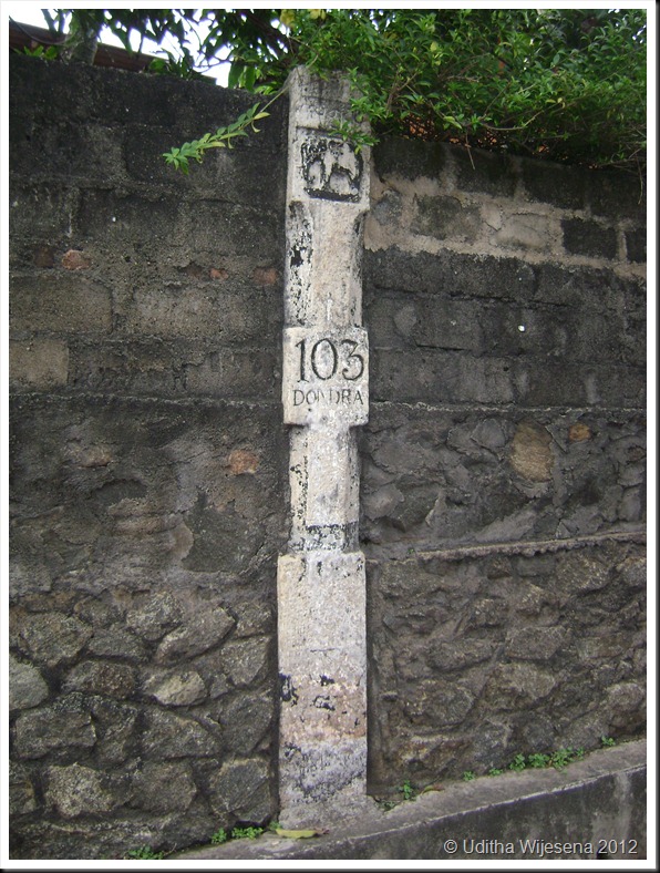
The 103 rd milepost on the A2 route from Colombo to Wellaway is not in line with the standard mile post and is excessively tall to be 90 inches above ground and 10.5 inches wide. To stand at 90 inches above ground it should measure at least another  40 inches below ground. 


I tried my best to get to the history behind this but with no avail. Nihal Fernando the veteran Travel Photographer notes in his book  by Studio Times “The Handbook for the Ceylon Traveller” ; it is probably carved out of a temple pillar, but does not speculate to its speciality. 

And why is it now built into a wall is again a mystery. Probably for stability but needs to be dealt with properly during the forth coming  road widening for it is special not just for its height. 

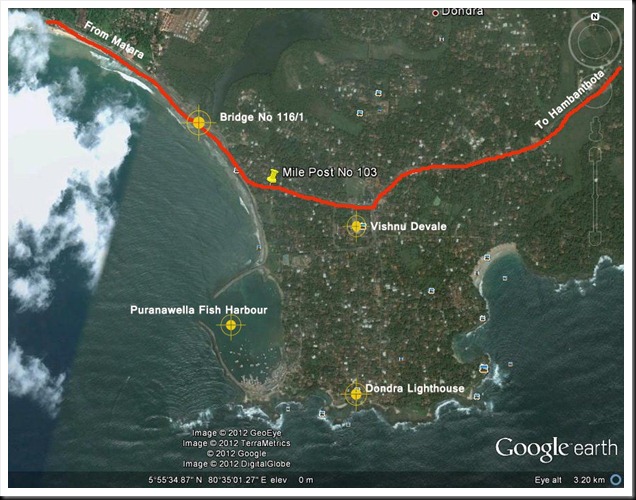
It is geographically the south most milepost in our country. You will not miss it. It is right opposite the Peoples Bank at Devinuwara [Dondra] on the land side just after the bridge number 116/1. 

Mile Post

Pose with it for your picture; its over 7 feet tall and you can say that you've been  to the south most milepost  in the island. This way it would be preserved for the future generations. 

DSC05048


DSC05049
 
 
Finally I would like to speculate on the elephant figure on it. It may be a memorial to a elephant that assisted in road building which may have passed away in the vicinity and the height may be a match to its height at the shoulder.  


Sunday, June 10, 2012

Those Engineering Marvels on the Sri Lankan Railway to Badulla

Trains and train journeys have fascinated both children and adults ever since they were invented. Likewise railway lines on which they run have posed challenges to engineers and surveyors when laying them on difficult terrain. Railways are far more different to highways; they cannot negotiate sharp bends and inclines, and the specified gradients for railway lines have not changed much even in the modern times. These limitations have posed challenges to railway line designers in hilly terrain that require innovative civil engineering structures to bridge waterways, gorges, and valleys and the need to tunnel through hills in order to maintain specified gradients. As a result much of the world’s railways in the elevated terrain have opened up fabulous vistas and landscapes to be enjoyed while journeying through. 

Curtsy; http://dayabaran-nature.blogspot.com/2011/03/kadugannawa.html   

Blasted  rock resemble a lion's mouth - Kadugannawa pass
Sri Lanka's railways  began in 1864 during the British colonial era and are nine lines radiating from Colombo. The mainline to Badulla which travels via Kandy is a run of 181 miles that takes a circuitous route in the hills through tea estates, pine forests and misty peaks passing picturesque waterfalls and hair-raising precipices. It is recorded that it was no ordinary task building the upcountry line in keeping to the specified limiting gradient of 1 on 44 - [2.27%]. Many were the challenges that took 60 years to lay the 181 miles of broad gauge rails [5’ 6”] to Badulla. The line traverses through 46 tunnels and over towering dressed-stone piers which hold steel bridges that were formed in distant Glasgow and Liverpool.
Curtsy: sundayobserver.lk
Steel Bridges spanned on tall dressed stone piers
This line which commences in Colombo at an elevation of 14 ft. MSL reaches Pattipola its summit at an elevation of 6226 ft. MSL after traversing a distance of 139 miles. The descend from Pattipola to Badulla is said to have run into major engineering challenges due to topographical conditions that did not suite the general specifications and the required gradients. Reaching Badulla located at an elevation of 2200 ft. MSL became  almost impossible beyond Demodara as the topography was far too steep for the track to negotiate. 

Looping the loop Paint copy
Looping the loop at Demodara to reach Badulla

Legend has it that a Kangani [colloquial for Foreman /charge hand] having finished his days’ work and was tying his turban; wrapping the long cloth round his head crossing the strands over the other and tucking the loose end in the strands. The engineer seeing the way he set the turban firm on his head crossing the strands over the other, is said to have been triggered off with an idea to break the dead lock at Demodara.

Finally it was Sri Lanka’s eminent engineering maestro of that time D J Wimalasurendra who with other engineers managed to create the 'Looping the Loop" line which traverses under the Demodara station through a tunnel gaining the extra mileage needed to keep to the required gradient to reach Badulla in 1924. As a result of these topographical challenges, Demodara and its vicinity is world renowned in the history of railways; while these structures in the Demodara and the Ella region are unique engineering masterpieces that serve the Sri Lankan Railway to this day. 

Nine Arch Bridge copy
Winding its way from Demodara to Bandarawela over the Nine Arch Bridge

The Nine Arched Bridge. 

The nine arched bridge at 169.75 miles between Ella and Demodara is a massive dressed stone structure that was needed to maintain the contour. It is  the only one of its kind in the island. The structure is earth filled within and the track laid on ballast giving the impression that the train is traversing on an oversized culvert. 

Much of these scenic legendary cannot be enjoyed while traveling on rail. One needs to cut in through the difficult terrain off the Bandarawela - Badulla motor way and trek on to the railway line to visualize these unique and gigantic engineering marvels.

The Nine Arch Bridge emerging from Tunnel No 40
Nine Arches at 169 .75 miles from Colombo
Earth filled within and track laid on ballast depicting a oversized culvert

The two Sandaruwans'  who showed me the way to the Nine Arches - [They both have the same name]

Monday, April 23, 2012

The Bird-Bill….a unique adaptation for survival

 
The bill or beak for a bird is the most versatile anatomical component adapted for its survival. Apart from the common physical features of a feather covered body and egg-laying for breeding; it is the bill and the feet of a bird that vary according to the food and the habitat they dwell upon.

The stout  and strong bill of the crow
Extremes in bill shape are many. The bill of a crow may be considered a good example of an all-round tool. It is stout and fare in size being strong enough to kill small mammals and opening nuts. Fine enough at the tip for picking small insects etc. Woodpeckers which search for wood boring insects have chisel like bills for cutting holes in trees while the hooked bill of the birds of prey are for tearing flesh. Sand pipers, Woodcocks and Snipe have long probe-like bills for probing worms and invertebrates out of mud. Another unique adaptation is shown by the broad bill of the duck and the scoop like bill of the flamingo which has a sieve-like fringe along the sides. A mouthful of water taken and forced out through the fringes trapping microscopic larvae, algae, snails, insects and seeds to be consumed as food. Yet another extreme bill design is that of the Nightjars, Swifts and Swallows which catch insects on the wing. The reduction of the horny bill is related to the extra-large increase in the gape size. 

Curtsy - Sarath Kotagam / Gamimi Ratnaweera                
Birds grouped according to bill types  
                                                                                                                                       
Competition for food on a common feeding ground is managed by the bill shapes controlling exploitation of natural resources. The nectar in a flower is shared based on the reachable depth of the Sunbird's bill into the corolla tube of a flower. A bird with a shorter bill feeding first at the flower leaves a share for the longer billed. 

The most unique form of habitat sharing when feeding is among the waders and shorebirds. Waders and Shorebirds accounts for the largest species diversity in the avian world and much of them migrate from the temperate breeding grounds in the northern hemisphere to tropical feeding grounds during winter. Classified as ‘waders and shorebirds’ it implies that their survival is highly dependent on the wetlands. 

The estuaries and wetlands where the waders feed in winter are the most productive ecosystems in the world. The rivers bring in fresh water which is high in nutrients to mix in the estuaries with the saline water. The resulting intertidal mud flats support and raise an abundance of invertebrates of a limited range of species. 

Waders find their prey by sight and touch and at times by a combination of both these and by hearing as well. How they feed depends on their prey and where they feed. 

Sight feeding waders are characterized by their short bills and large eyes for acute sight. Sight feeders generally feed with ample space between one another. Being too close they would dash for the same prey wasting precious energy and time. Distraction of other birds will make each one a less efficient hunter while the chance of the prey to escape is also high. Plovers and Lapwings are sight feeders and use same ‘run & pause’ technique. Their long legs aid them to dash forward, pause and bend their heads rapidly to catch sight or sound of the prey. Plovers and Lapwings also use the ‘foot – trembling’; tapping its foot rapidly on the ground to disturb the prey and trick it to move disclosing its whereabouts. Plovers, Lapwings, Stints, Thick- knees all fall under the category of sight feeders. They are most active during the day time and the food is smaller prey which they have to consume in large quantities. 

The Redshank is a sight-feeder by day on mudflats feeding on shrimp which they find by sight. The flocks of day feeding Redshanks are much looser than when at night feeding on snails by touch, which brings them nearer to work in a close flock. 

Sandpipers are rapid feeders, also locating their prey by sight. Turnstones use their short bills to hammer open barnacles. 

Several species of waders probe beneath the surface to locate prey by touch. However none seem to feed exclusively by touch only. Some of them also pick food from the surface through sight, while probing is not entirely unintentional and sight is used to identify where to probe. Snipe with their long sensitive bills are highly efficient probers and are mainly active feeders in the night. 

The Curlew is a skillful prober fully inserting their bill in the mud but will also take the small crabs on the surface by pecking and grabbing them from beneath the surface of water by sight. When probing for larger prey beneath the surface to be able to grip the prey at the tip of the bill most probers can flex the tip of their upper mandible. Thus a wader can open the tip of the bill without opening the base of the bill. The Whimbrel probes from half depth to full bill depth and will move its head to change the angle and is able to extract and swallow its prey without completely withdrawing the bill.

Curtsy - Muthurajawela wetland report 

Structural adaptation of bills of wading birds for feeding at different depths in  a sand shoal

The heaviest bills among the waders are of the Oystercatchers. Their hefty bills are subjected to enormous wear and tear. Used in a number of ways, to prise open cockerel, knock mussels from anchorages, to stab into bivalves, smash shells etc. The shape of the bill of an Oystercatcher will give a clue to its feeding specialization. A square ended bill like that of a chisel end for those that hammer open mussels through weak points and pointed end for those that open mussels at the point where the shell closes. The horn like material covering their bills ware-off and the pointed ends would become square with usages. This wearing is such that the bills continue to grow very rapidly for the survival of the bird. This is unique among waders and it is said to grow at a rapid rate of 0.4 mm per day, which is three times faster than the growth of the human fingernail.


Even with such adaptability it is not that easy to locate prey with the changing temperatures and climates. In wintery atmospheres the ground temperatures drop and relatively the prey burrow deep to find warmth. The birds need to wait till the temperatures are right for them to surface. Likewise over here the most productive wetlands situated in the South East and North West arid zones get very warm during the day and the prey tend burrow deep to avoid the excess heat. Changing winds form ripples on the water surface barring sight and focus. Continuous deep probing for larger prey has the disadvantage of heat loss into the cold surrounding ground resulting in energy loss. This brings the bird to a resting position until the lost energy is gained through digestion. 

We bird lovers on the other hand frequent these wetlands as they are the ideal lookouts to identify and spot the rear migrant in their intricate winter plumages. Global warming and human intervention by encroaching and dumping has gradually threatened the healthy well-being of these wetlands. Deterioration of the wetlands will affect the survival of the world wader population that have evolved and migrated for thousands of years. So let’s take to our hearts the need to preserve, protect, and present them… wetlands for the future birders and waders………..