Sunday, June 24, 2012

It stands tall …..tight in a wall

Units of measurement were among the earliest tools invented by humans. Among them distance was primeval.
.  
History records of a early Cubit used in the Indus valley in the 3rd millennium BC. The measures of length used in ancient India included the dhanus (bow), the krosa (cry, or cow-call) and the yojana (stage). 
 
Yojana may be the equivalent to Sri Lanka’s Yoduna while we also had the Hooowa; the furthest distance the human hoot could be heard, 
 
Romans invented mille passes; one thousand [1000] paces or double steps. A pace was equal to five Roman feet [approximately 1480 mm]. and the Roman foot approximated 296mm. The Roman mile of 5000 feet was introduced to England during their occupation, and it is said that Queen Elizabeth I [1558-1603] changed its status to 5280 feet. Its interesting to note how, why and who made school mathematics so complicated? 
 
From then on every where the British went so did the mile and the milestone that kept on adding on the length of the roads they built. In Sri Lanka they were carved out of granite and the mileage and the name of the township hued out on it. They were planted along the road to specification on the left side of the road from origination to destination. 
 
Just as specifications and codes of practice are to keep to uniformity, there are exceptions. Of all the hundreds of milestones produced by the Public Works Department [PWD] then, there is but one exception that is still to be seen even though the Kilometre has come to stay with us on the right hand side of the road since the early 70’s.
 
The 103 rd milepost on the A2 route from Colombo to Wellaway is not in line with the standard mile post and is excessively tall to be 90 inches above ground and 10.5 inches wide. To stand at 90 inches above ground it should measure at least another  40 inches below ground. 


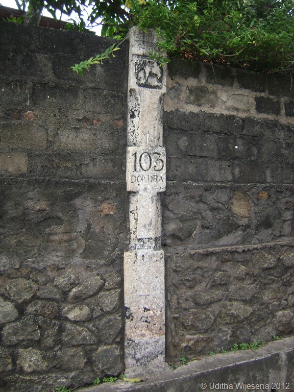
I tried my best to get to the history behind this but with no avail. Nihal Fernando the veteran Travel Photographer notes in his book  by Studio Times “The Handbook for the Ceylon Traveller” ; it is probably carved out of a temple pillar, but does not speculate to its speciality. 

And why is it now built into a wall is again a mystery. Probably for stability but needs to be dealt with properly during the forth coming  road widening for it is special not just for its height. 

It is geographically the south most milepost in our country. You will not miss it. It is right opposite the Peoples Bank at Devinuwara [Dondra] on the land side just after the bridge number 116/1. 

Mile Post

Pose with it for your picture; its over 7 feet tall and you can say that you've been  to the south most milepost  in the island. This way it would be preserved for the future generations. 

DSC05048


DSC05049
 
 
Finally I would like to speculate on the elephant figure on it. It may be a memorial to a elephant that assisted in road building which may have passed away in the vicinity and the height may be a match to its height at the shoulder.  


Sunday, June 10, 2012

Those Engineering Marvels on the Sri Lankan Railway to Badulla

Trains and train journeys have fascinated both children and adults ever since they were invented. Likewise railway lines on which they run have posed challenges to engineers and surveyors when laying them on difficult terrain. Railways are far more different to highways; they cannot negotiate sharp bends and inclines, and the specified gradients for railway lines have not changed much even in the modern times. These limitations have posed challenges to railway line designers in hilly terrain that require innovative civil engineering structures to bridge waterways, gorges, and valleys and the need to tunnel through hills in order to maintain specified gradients. As a result much of the world’s railways in the elevated terrain have opened up fabulous vistas and landscapes to be enjoyed while journeying through. 

Curtsy; http://dayabaran-nature.blogspot.com/2011/03/kadugannawa.html   

Blasted  rock resemble a lion's mouth - Kadugannawa pass
Sri Lanka's railways  began in 1864 during the British colonial era and are nine lines radiating from Colombo. The mainline to Badulla which travels via Kandy is a run of 181 miles that takes a circuitous route in the hills through tea estates, pine forests and misty peaks passing picturesque waterfalls and hair-raising precipices. It is recorded that it was no ordinary task building the upcountry line in keeping to the specified limiting gradient of 1 on 44 - [2.27%]. Many were the challenges that took 60 years to lay the 181 miles of broad gauge rails [5’ 6”] to Badulla. The line traverses through 46 tunnels and over towering dressed-stone piers which hold steel bridges that were formed in distant Glasgow and Liverpool.
Curtsy: sundayobserver.lk
Steel Bridges spanned on tall dressed stone piers
This line which commences in Colombo at an elevation of 14 ft. MSL reaches Pattipola its summit at an elevation of 6226 ft. MSL after traversing a distance of 139 miles. The descend from Pattipola to Badulla is said to have run into major engineering challenges due to topographical conditions that did not suite the general specifications and the required gradients. Reaching Badulla located at an elevation of 2200 ft. MSL became  almost impossible beyond Demodara as the topography was far too steep for the track to negotiate. 

Looping the loop Paint copy
Looping the loop at Demodara to reach Badulla

Legend has it that a Kangani [colloquial for Foreman /charge hand] having finished his days’ work and was tying his turban; wrapping the long cloth round his head crossing the strands over the other and tucking the loose end in the strands. The engineer seeing the way he set the turban firm on his head crossing the strands over the other, is said to have been triggered off with an idea to break the dead lock at Demodara.

Finally it was Sri Lanka’s eminent engineering maestro of that time D J Wimalasurendra who with other engineers managed to create the 'Looping the Loop" line which traverses under the Demodara station through a tunnel gaining the extra mileage needed to keep to the required gradient to reach Badulla in 1924. As a result of these topographical challenges, Demodara and its vicinity is world renowned in the history of railways; while these structures in the Demodara and the Ella region are unique engineering masterpieces that serve the Sri Lankan Railway to this day. 

Nine Arch Bridge copy
Winding its way from Demodara to Bandarawela over the Nine Arch Bridge

The Nine Arched Bridge. 

The nine arched bridge at 169.75 miles between Ella and Demodara is a massive dressed stone structure that was needed to maintain the contour. It is  the only one of its kind in the island. The structure is earth filled within and the track laid on ballast giving the impression that the train is traversing on an oversized culvert. 

Much of these scenic legendary cannot be enjoyed while traveling on rail. One needs to cut in through the difficult terrain off the Bandarawela - Badulla motor way and trek on to the railway line to visualize these unique and gigantic engineering marvels.

The Nine Arch Bridge emerging from Tunnel No 40
Nine Arches at 169 .75 miles from Colombo
Earth filled within and track laid on ballast depicting a oversized culvert

The two Sandaruwans'  who showed me the way to the Nine Arches - [They both have the same name]