Sunday, June 24, 2012

It stands tall …..tight in a wall

Units of measurement were among the earliest tools invented by humans. Among them distance was primeval.
.  
History records of a early Cubit used in the Indus valley in the 3rd millennium BC. The measures of length used in ancient India included the dhanus (bow), the krosa (cry, or cow-call) and the yojana (stage). 
 
Yojana may be the equivalent to Sri Lanka’s Yoduna while we also had the Hooowa; the furthest distance the human hoot could be heard, 
 
Romans invented mille passes; one thousand [1000] paces or double steps. A pace was equal to five Roman feet [approximately 1480 mm]. and the Roman foot approximated 296mm. The Roman mile of 5000 feet was introduced to England during their occupation, and it is said that Queen Elizabeth I [1558-1603] changed its status to 5280 feet. Its interesting to note how, why and who made school mathematics so complicated? 
 
From then on every where the British went so did the mile and the milestone that kept on adding on the length of the roads they built. In Sri Lanka they were carved out of granite and the mileage and the name of the township hued out on it. They were planted along the road to specification on the left side of the road from origination to destination. 
 
Just as specifications and codes of practice are to keep to uniformity, there are exceptions. Of all the hundreds of milestones produced by the Public Works Department [PWD] then, there is but one exception that is still to be seen even though the Kilometre has come to stay with us on the right hand side of the road since the early 70’s.
 
The 103 rd milepost on the A2 route from Colombo to Wellaway is not in line with the standard mile post and is excessively tall to be 90 inches above ground and 10.5 inches wide. To stand at 90 inches above ground it should measure at least another  40 inches below ground. 
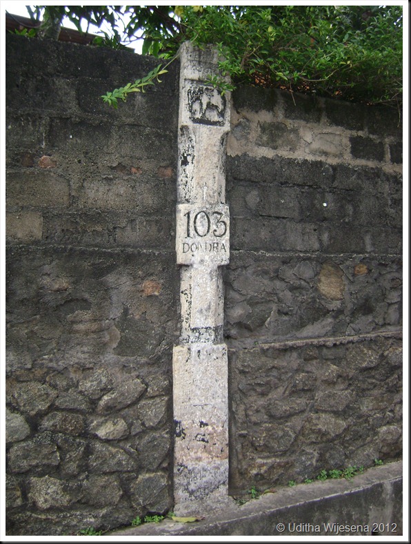
  

I tried my best to get to the history behind this but with no avail. Nihal Fernando the veteran Travel Photographer notes in his book  by Studio Times “The Handbook for the Ceylon Traveller” ; it is probably carved out of a temple pillar, but does not speculate to its speciality. 

And why is it now built into a wall is again a mystery. Probably for stability but needs to be dealt with properly during the forth coming  road widening for it is special not just for its height. 

It is geographically the south most milepost in our country. You will not miss it. It is right opposite the Peoples Bank at Devinuwara [Dondra] on the land side just after the bridge number 116/1. 
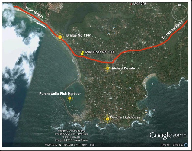
Mile Post

Pose with it for your picture; its over 7 feet tall and you can say that you've been  to the south most milepost  in the island. This way it would be preserved for the future generations. 

DSC05048


DSC05049
 
 
Finally I would like to speculate on the elephant figure on it. It may be a memorial to a elephant that assisted in road building which may have passed away in the vicinity and the height may be a match to its height at the shoulder.  


Sunday, June 10, 2012

Those Engineering Marvels on the Sri Lankan Railway to Badulla

Trains and train journeys have fascinated both children and adults ever since they were invented. Likewise railway lines on which they run have posed challenges to engineers and surveyors when laying them on difficult terrain. Railways are far more different to highways; they cannot negotiate sharp bends and inclines, and the specified gradients for railway lines have not changed much even in the modern times. These limitations have posed challenges to railway line designers in hilly terrain that require innovative civil engineering structures to bridge waterways, gorges, and valleys and the need to tunnel through hills in order to maintain specified gradients. As a result much of the world’s railways in the elevated terrain have opened up fabulous vistas and landscapes to be enjoyed while journeying through. 

Curtsy; http://dayabaran-nature.blogspot.com/2011/03/kadugannawa.html   

Blasted  rock resemble a lion's mouth - Kadugannawa pass
Sri Lanka's railways  began in 1864 during the British colonial era and are nine lines radiating from Colombo. The mainline to Badulla which travels via Kandy is a run of 181 miles that takes a circuitous route in the hills through tea estates, pine forests and misty peaks passing picturesque waterfalls and hair-raising precipices. It is recorded that it was no ordinary task building the upcountry line in keeping to the specified limiting gradient of 1 on 44 - [2.27%]. Many were the challenges that took 60 years to lay the 181 miles of broad gauge rails [5’ 6”] to Badulla. The line traverses through 46 tunnels and over towering dressed-stone piers which hold steel bridges that were formed in distant Glasgow and Liverpool.
Curtsy: sundayobserver.lk
Steel Bridges spanned on tall dressed stone piers
This line which commences in Colombo at an elevation of 14 ft. MSL reaches Pattipola its summit at an elevation of 6226 ft. MSL after traversing a distance of 139 miles. The descend from Pattipola to Badulla is said to have run into major engineering challenges due to topographical conditions that did not suite the general specifications and the required gradients. Reaching Badulla located at an elevation of 2200 ft. MSL became  almost impossible beyond Demodara as the topography was far too steep for the track to negotiate. 

Looping the loop Paint copy
Looping the loop at Demodara to reach Badulla

Legend has it that a Kangani [colloquial for Foreman /charge hand] having finished his days’ work and was tying his turban; wrapping the long cloth round his head crossing the strands over the other and tucking the loose end in the strands. The engineer seeing the way he set the turban firm on his head crossing the strands over the other, is said to have been triggered off with an idea to break the dead lock at Demodara.

Finally it was Sri Lanka’s eminent engineering maestro of that time D J Wimalasurendra who with other engineers managed to create the 'Looping the Loop" line which traverses under the Demodara station through a tunnel gaining the extra mileage needed to keep to the required gradient to reach Badulla in 1924. As a result of these topographical challenges, Demodara and its vicinity is world renowned in the history of railways; while these structures in the Demodara and the Ella region are unique engineering masterpieces that serve the Sri Lankan Railway to this day. 

Nine Arch Bridge copy
Winding its way from Demodara to Bandarawela over the Nine Arch Bridge

The Nine Arched Bridge. 

The nine arched bridge at 169.75 miles between Ella and Demodara is a massive dressed stone structure that was needed to maintain the contour. It is  the only one of its kind in the island. The structure is earth filled within and the track laid on ballast giving the impression that the train is traversing on an oversized culvert. 

Much of these scenic legendary cannot be enjoyed while traveling on rail. One needs to cut in through the difficult terrain off the Bandarawela - Badulla motor way and trek on to the railway line to visualize these unique and gigantic engineering marvels.

The Nine Arch Bridge emerging from Tunnel No 40
Nine Arches at 169 .75 miles from Colombo
Earth filled within and track laid on ballast depicting a oversized culvert

The two Sandaruwans'  who showed me the way to the Nine Arches - [They both have the same name]

Monday, April 23, 2012

The Bird-Bill….a unique adaptation for survival

 
The bill or beak for a bird is the most versatile anatomical component adapted for its survival. Apart from the common physical features of a feather covered body and egg-laying for breeding; it is the bill and the feet of a bird that vary according to the food and the habitat they dwell upon.

The stout  and strong bill of the crow
Extremes in bill shape are many. The bill of a crow may be considered a good example of an all-round tool. It is stout and fare in size being strong enough to kill small mammals and opening nuts. Fine enough at the tip for picking small insects etc. Woodpeckers which search for wood boring insects have chisel like bills for cutting holes in trees while the hooked bill of the birds of prey are for tearing flesh. Sand pipers, Woodcocks and Snipe have long probe-like bills for probing worms and invertebrates out of mud. Another unique adaptation is shown by the broad bill of the duck and the scoop like bill of the flamingo which has a sieve-like fringe along the sides. A mouthful of water taken and forced out through the fringes trapping microscopic larvae, algae, snails, insects and seeds to be consumed as food. Yet another extreme bill design is that of the Nightjars, Swifts and Swallows which catch insects on the wing. The reduction of the horny bill is related to the extra-large increase in the gape size. 

Curtsy - Sarath Kotagam / Gamimi Ratnaweera                
Birds grouped according to bill types  
                                                                                                                                       
Competition for food on a common feeding ground is managed by the bill shapes controlling exploitation of natural resources. The nectar in a flower is shared based on the reachable depth of the Sunbird's bill into the corolla tube of a flower. A bird with a shorter bill feeding first at the flower leaves a share for the longer billed. 

The most unique form of habitat sharing when feeding is among the waders and shorebirds. Waders and Shorebirds accounts for the largest species diversity in the avian world and much of them migrate from the temperate breeding grounds in the northern hemisphere to tropical feeding grounds during winter. Classified as ‘waders and shorebirds’ it implies that their survival is highly dependent on the wetlands. 

The estuaries and wetlands where the waders feed in winter are the most productive ecosystems in the world. The rivers bring in fresh water which is high in nutrients to mix in the estuaries with the saline water. The resulting intertidal mud flats support and raise an abundance of invertebrates of a limited range of species. 

Waders find their prey by sight and touch and at times by a combination of both these and by hearing as well. How they feed depends on their prey and where they feed. 

Sight feeding waders are characterized by their short bills and large eyes for acute sight. Sight feeders generally feed with ample space between one another. Being too close they would dash for the same prey wasting precious energy and time. Distraction of other birds will make each one a less efficient hunter while the chance of the prey to escape is also high. Plovers and Lapwings are sight feeders and use same ‘run & pause’ technique. Their long legs aid them to dash forward, pause and bend their heads rapidly to catch sight or sound of the prey. Plovers and Lapwings also use the ‘foot – trembling’; tapping its foot rapidly on the ground to disturb the prey and trick it to move disclosing its whereabouts. Plovers, Lapwings, Stints, Thick- knees all fall under the category of sight feeders. They are most active during the day time and the food is smaller prey which they have to consume in large quantities. 

The Redshank is a sight-feeder by day on mudflats feeding on shrimp which they find by sight. The flocks of day feeding Redshanks are much looser than when at night feeding on snails by touch, which brings them nearer to work in a close flock. 

Sandpipers are rapid feeders, also locating their prey by sight. Turnstones use their short bills to hammer open barnacles. 

Several species of waders probe beneath the surface to locate prey by touch. However none seem to feed exclusively by touch only. Some of them also pick food from the surface through sight, while probing is not entirely unintentional and sight is used to identify where to probe. Snipe with their long sensitive bills are highly efficient probers and are mainly active feeders in the night. 

The Curlew is a skillful prober fully inserting their bill in the mud but will also take the small crabs on the surface by pecking and grabbing them from beneath the surface of water by sight. When probing for larger prey beneath the surface to be able to grip the prey at the tip of the bill most probers can flex the tip of their upper mandible. Thus a wader can open the tip of the bill without opening the base of the bill. The Whimbrel probes from half depth to full bill depth and will move its head to change the angle and is able to extract and swallow its prey without completely withdrawing the bill.

Curtsy - Muthurajawela wetland report 

Structural adaptation of bills of wading birds for feeding at different depths in  a sand shoal

The heaviest bills among the waders are of the Oystercatchers. Their hefty bills are subjected to enormous wear and tear. Used in a number of ways, to prise open cockerel, knock mussels from anchorages, to stab into bivalves, smash shells etc. The shape of the bill of an Oystercatcher will give a clue to its feeding specialization. A square ended bill like that of a chisel end for those that hammer open mussels through weak points and pointed end for those that open mussels at the point where the shell closes. The horn like material covering their bills ware-off and the pointed ends would become square with usages. This wearing is such that the bills continue to grow very rapidly for the survival of the bird. This is unique among waders and it is said to grow at a rapid rate of 0.4 mm per day, which is three times faster than the growth of the human fingernail.


Even with such adaptability it is not that easy to locate prey with the changing temperatures and climates. In wintery atmospheres the ground temperatures drop and relatively the prey burrow deep to find warmth. The birds need to wait till the temperatures are right for them to surface. Likewise over here the most productive wetlands situated in the South East and North West arid zones get very warm during the day and the prey tend burrow deep to avoid the excess heat. Changing winds form ripples on the water surface barring sight and focus. Continuous deep probing for larger prey has the disadvantage of heat loss into the cold surrounding ground resulting in energy loss. This brings the bird to a resting position until the lost energy is gained through digestion. 

We bird lovers on the other hand frequent these wetlands as they are the ideal lookouts to identify and spot the rear migrant in their intricate winter plumages. Global warming and human intervention by encroaching and dumping has gradually threatened the healthy well-being of these wetlands. Deterioration of the wetlands will affect the survival of the world wader population that have evolved and migrated for thousands of years. So let’s take to our hearts the need to preserve, protect, and present them… wetlands for the future birders and waders………..

Monday, March 19, 2012

St Clair's False……?

Of all Sri Lanka's development projects considered…. it was the Upper Kotmale Hydro Power Project (UKHP) in Talawakele  that  had to face so much dissidence. The project had to be shelved at least on three occasions due to relocation factors, environmental factors and political factors.

However the euphoria that was to stay with the ending of the 30 year conflict in the country was to have discounted all such opposition. 

St Clair Pano Revised copy
St Clair's Falls in the hey day
UKHP is the last of the large scale hydroelectric projects conceived on the  master plan for hydroelectric development in the Mahaweli Basin in 1968. Feasibility studies conducted by the Japanese donors in the 85-87 period identified a reservoir project at Caledonia which was to displace over 2700 families and inundate a good portion of the best tea gardens in the country; thus the run of the river project with a diversion weir at Talawakelle being considered prudent.

The project is approved by the Secretary of the Ministry of Forestry and Environment under the National Environment Act in July 1998 subject to strict adoption of proposed mitigatory measures to minimise possible environmental impacts.This decision was challenged in the Court of Appeal in October 1998. Subsequent to the settlement in the appeal court, the Secretary of the Ministry of Forestry and Environment gives a final order in March 2000.

Talawakele Pano Revised copy
Largest re-location in a hydro power project in this country
The project realized with  many mitigratory factors. Maintaining  a daytime flow over the waterfalls was one such requirement.

Today the headworks are completed with the weir barraging the water that would otherwise have flowed over the St Clair's Falls is diverted to a tunnel that runs to Niyamgamdora for power generation. 

Ukot 1 copy
Barraged waters about 2 meters below capacity
The  water that we see cascading over the St Clair's Falls today; is but the  regulation water that is released as a requirement in the court order. 

DSC_0340 copy
Regulation waters released to the river to activate St Clair's falls - [March 3, 2012]
I do remember an incident way-back in year 2000 when the Japanese team approached an Environmental Academic attached to the University of Colombo in the height of the opposition to the project, to be briefed on the mitigatory factors. This Don was to say that he is not that very concerned about the water falls; for them would dwindle with the threatened environment and nobody would  know how they looked before the hills were stripped for tea and coffee. It is the project cost  that had almost tripled during the negotiations; which is far too in excess for a country like ours.
   
DSC_0358 - Copy copy
St Clair's with regulation water as seen on March 3, 2012
However the project is now here to stay with us, supplementing the large deficit in the country’s power sector. St Clair’s  Falls will still keep cascading while many would not know that it is false. The tea centre opposite the Devon and St Clair’s falls will still have guests until this false falls keep falling.

The Tea Centre overlooking the falls
A note on the positive aspect though; even this regulation view that we enjoy today will be complimented in time to come with the wanton destruction to the upper-watershed management area that goes unchecked. The  illicit forest clearing for cultivation etc. would find the said falls drying up for many months in an year, in the future. Now with the regulation flow we would still have the St Clair's falling without interruption for many more years.....? 

Saturday, March 3, 2012

Camping in the Appalachian Range

If there is anything that I like of the American,,,,, it is their liking for outdoors. This said…… it’s not that the  Europeans and the British do not like outdoors, but the American is more adventurous. They hike and camp in the rough rugged terrain of America  in groups or as loners frequently and document their personnel experiences.

Camping in the Smokies of the Appalachian Mountain Range was to be a novel experience to me from Sri Lanka’s premier outbound school in the hills of Gurutalawa, where hiking, running cross-country in the rain and camping in the  forested cool hillsides around Horton plains being the order of school life then in the 60’s. 

DSC_0527
The Appalachian in October
DSC_0735
 Across the summit of Appalachian


The Appalachian crossing borders
Having missed the opportunity to camp in the Everglades for climatic reasons on a short visit to Naveen, Bhagya and their son Mevan who was just one year old living in Florida; the  trip to the Appalachian  mountains  at the right time during the fall in October when the hills put out a array of colours was most welcoming although needing detailed planning. A  travel  distance of over 1000 kilometers from Miami up north  cutting across  Georgia, South & North Carolinas all the way to Gatlinburg in Tennessee. 

DSC_0696CSC_0727


DSC_0714
DSC_0767


Appalachian creates many hues every October

Foremost was a reliable mode of conveyance. We rented a Honda motor car for the trip. The bear minimum requisites of camping gear, warm clothes and baby food took much of the boot area which filled to capacity.

The departure from Miami was planned at 10.00 pm with the baby asleep, but  was delayed by an hour looking for a missing cable for the Garmin navigator. Finally it was decided to proceed on the the interstate highway to the border of Georgia and purchase a compatible cable in the morning.
 
Tired an weary through a crammed travel, we rested  at Sandy Beach Park, Moseley Georgia for over two hours napping and feeding the baby as planned.

DSC_0392DSC_0347


CSC_0407
CSC_0460


 Sandy Beach Park Moseley Georgia [Osprey and Mallard in lake that create the beach]  

The second leg of the travel commenced with the aid of the navigator but the distance and the time taken was very much more than expected in the foggy climate in the hilly terrain. However the destination for the night was reached by 10.00 pm, the  River Edge Motor Lodge, in Gatlinburg, Tenancy.  

DSC_0456DSC_0655


 River Edge Motor Lodge and Gatlinburg Inn

After a good nights' sleep we joined the  holidaying crowds in Gatlinburg that come alive every fall when many visit to see the  forest turn into a  to  multiple  hues. Also being just before  Halloween  the festivities was to be very much.

DSC_0474
DSC_0654


DSC_0649
DSC_0658


DSC_0537
Holidaymakers during Halloween time


We checked out by mid day and was at the Elkmont camping ground by evening; tents were put up even though the forecast for the night was heavy to moderate showers. Cooked a can of beans and some soup in a heavy drizzle, fanning and blowing into the dampened firewood; when suddenly, the sky come down.

DSC_0518
Setting up camp before night fall
DSC_0522
Elkmont campsite
DSC_0534DSC_0519


 Before the skies came down

A soggy situation in heavy wind was watched from within the car when the guy ropes of the tent flysheet giving away  and rain beating on the tent fabric direct. Such camping experience was not for a baby. Hemamala and I needed to brave the situation and decided to stay back while the baby with the parents had no choice except for the  River Edge Motor Lodge.

The flysheet was put back firmly when the wind died down and  were now lying in sleeping bags sans sleep waiting for the next thing to happen, while the rain continued into a black chilly night. A hour passed, and another when we now got the feeling of lying down on unset jelly. We had laid an extra  ground sheet under the tent and rain water was trapped between them and the water moving under us giving this jellylike feeling.

An extra long night had passed when morning came.The tents were dried and re-packed into the car and we proceeded to Cosby a distant campsite where the weather was to be favorable. Cosby was dry though chilly and the night being very cold. The warm clothing was able to keep us comfortable with the baby and all four in one tent, our body heat trapped within the tent fabric doing the trick for a good night’s sleep.Even the baby slept tight till morning. An extremely memorable camping trip.

DSC_0316
The Cosby campsite

DSC_0321DSC_0302


DSC_0331DSC_0325


 Grilled frankfurters and boiled rice for dinner

On the return it was with much aspiring feelings that we set foot on the famous  Appalachian Nature Trail that traverse the Appalachian summit. A distance of approximately 2,184 miles (3,515 km) that takes almost six months to complete on foot. Sections of it is traversed by many. Naveen made a vow to come back after his graduation for a week’s backpacking on the bear inhabited trail. A wish that would never come true for me.


DSC_0528
DSC_0750
DSC_0758
The Appalachian Nature Trail with regulation
DSC_0757DSC_0753


 We have been on the Appalachian Trail


On the way back a traffic jam extending almost a mile on either side was due to a mother bear and  cub displaying acrobatics on a way side tree.

DSC_0682

DSC_0793