
The planet earth that we live in
has had drastic changes to its profile and its climate from time to time due to
natural disasters, changing weather patterns and very recently by acts of man.
Development related to Civil Engineering activities for economic growth, housing
and energy use have impacted the earth very much in the past century than from
natural calamities during the past millennium. This effect is significant in
the developing countries with the advancement of technology and the over
exploitation of natural resources in the manufacture of cement, steel and other
building materials needed for development.
Apart from these developments it
is also noted that some of man’s greatest monumental creations, where his
individual skills and craftsmanship of ethnic groupings have also had to be
abandoned or destroyed for overriding priorities of his energy needs and
communication requirements of the 21st century.
When the ancient Roman city of Pompii
was destroyed through natural disaster due to the irruption of the volcano Vesuvius
in A.D. 79, much of its brilliant Roman architecture and sculptures were
destroyed beyond redemption. The Kingdom of Cleopatra VII Philopator, the last
Pharaoh of Ancient Egypt is found settled beneath the waters of the
Mediterranean close to Alexandria; again due to a result of volcanic activity
and tidal waves that shaped that part of the world differently. Some classical Hindu and Buddhist dynasties
have also been swallowed by the sea due to sinking land areas in the South-East
Asian archipelago near Bali.
In comparison numerous are the
locations in the world that have been reshaped due to both natural and man
involved activity. Landscapes have been sunken in reservoirs or destroyed
completely to make way for new communication and roadways. Again there has been
concerns of economic benefits and historical value in them resulting in restoration
and relocation of some of his greatest creations for preservation. The
multipurpose Aswan Dam built in Egypt for power and agricultural needs; inundated the famous Abu Simbel Temple in Nubia in Southern Egypt. This temple
built by Pharaoh Ramesses II in the 13th century BC, as a lasting monument to
himself and his queen Nefertari, to commemorate his victory at the Battle of
Kadesh is iconic with its huge external rock relief figures. This temple was relocated in its entirety in 1968 after much debate on the subject even after it was drowned in the Aswan reservoir.
 |
| Pic Curtsey Google images The original Abu Simbel Temple 1927 |
 |
| Pic Curtsey Google images Abu Simbel after relocation |
Video Curtesy Youtube
Here at home a similar activity was undertaken by the Department of Archeology in rebuilding the Nalanda Gedige at its original footprint but on a built up mound within the reservoir created by the Bowatenne Dam. This stone structure was dismantled after carefully numbering and sketching each unit of stone for reference in the rebuilding. Today in this digital era these are not difficult undertakings but was not so in 1981 when Sri Lanka lacked such technology.
 |
| Pic Uditha Wijesena Nalanda Gedige rebuilt after dismantling |
 |
| Pic Uditha Wijesena |
 |
| Pic Uditha Wijesena Nalanda Gedige a Hindu influenced structure of ancient Sri Lanka is said to be located at almost the mid center of the island |
However there are other treasured
artifacts that have been lost forever in these man made reservoirs. Sri Lanka in the mid-20th century
had no option but to venture into hydroelectric power generation taking advantage of its topography in the central massif and the abundant
precipitation received from the South-West monsoon on the South-West slopes. The first such
project was commissioned in 1950. The Norton-bridge project or the Old Laxapana Reservoir
scheme. This dam became significant when the people of the tea estate community
was relocated as result of the township of Maskeliya being inundated. People
were relocated but they had to leave behind some precious places of religious
importance that was submerged in the rising waters behind the dam. The Hindi Kovils
and Buddhist Temples that submerged in these waters did surface from time to time during prolonged droughts. This initially created a nostalgia among the people and they visited these shrines for veneration as a special privilege which was considered incidental and rare. But today it is not so significant
due to the generation gap with those who venerated in these shrines are no longer living.
Subsequently the accelerated
Mahaveli Multipurpose Scheme saw much more of such hydroelectric power
generation reservoirs coming up around the ancient city of Kandy. These reservoirs needed
to relocate the communities living in the locality which did destroy much of the monumental sites and
townships in the vicinity.
 |
| Pic Uditha Wijesena |
 |
| Pic Uditha Wijesena Victoria Dam |
The Victoria Dam closer to Kandy
City submerged the total township of Teldeniya and its suburbs not
sparing the famous Victoria Falls either. But the falls did substitute the new reservoir
created by adapting its name. The people of these suburban villages had a very high
cultural lineage to the Kandian ethos and Architecture. These people did
contribute immensely both traditionally and loyally to the Temple of the Tooth and
its customs. The authorities resettled them as community units in the new
lands in the dry zone of Sri Lanka expecting the continuity of their ethnic and
cultural links. This was not to be so, and found themselves scattered from their
initial ways of life and the common bondage they had had with religious links
to the Temple of the Tooth. The impact in adjusting to these new
homesteads in a faraway land with a different climate in a new habitat was a very complicated task.
 |
| Pic Uditha Wijesena The Randingala Dam the largest in the Mahaveli river |
The largest man made hydroelectric
waterbody in this land was created with the damming of the Mahaveli River
downstream of the Victoria Reservoir, creating the Randenigala Reservoir. Even
though this dam and the reservoir came up in an area not inhabited by people,
it too did submerge a unique cave formation located in Isthripura, Sarasuntenna. Though there is another set of caves by the namesake close to Welimada
linked to the epic Ramayana, this cave is said to be linked with King Rajasinghe
II, the famous concupiscent king of Kandy who preferred to relax with his
concubines in these caves while on his numerous state visits in the hill
kingdom. The river flowing over the limestone formation leached into the cave
to form a wondrous series of breathtaking stalagmite and stalactite that would
have taken millions of years to form.
Alas… This was in no way possible to be relocated of restored but was made to be hidden in the backwater never to be seen again. The authorities took no action to photo record these caves before inundation. Either to avoid the opposition from the masses or through shear ignorance of its existence. People were not in the habit of adventurous travel then and the existence of the caves were known only to a few.
Alas… This was in no way possible to be relocated of restored but was made to be hidden in the backwater never to be seen again. The authorities took no action to photo record these caves before inundation. Either to avoid the opposition from the masses or through shear ignorance of its existence. People were not in the habit of adventurous travel then and the existence of the caves were known only to a few.
 |
| Pic Curtsey Google images Rantambe waters that submerged the Minipe Anicut and the Rantambe gorge |
The smaller reservoir that was
created lower to Randenigala again for power generation is the Rantambe
Reservoir. This did inundate the famous ancient Minipe Anicut which diverted the Mahaveli water to Pollonnaruwa via Amban Ganga from the Minipe Yoda Ela
irrigating the left bank of the Mahaveli. Built in AD 459 by King Dasankeliya,
today there is a new Minipe Diversion Weir irrigating both the right and the
left banks of the Mahaveli. Also this
small reservoir did inundate a unique land formation called the Rantambe
Gorge the only of its kind in the country. A narrow gap in a granite wall
measuring over 50 feet in depth and around 20 feet wide sitting across the path of the river. The river was forced to
rush through this throat emanating a thunderous roar that disturbed the
otherwise quiet wilderness when it ran with its banks full. Again it is
said that King Rajasinghe II who possessed great riding skills had been
in the habit of clearing this gorge on horseback.
Kotmale Reservoir located as the
most elevated reservoir in this series of reservoirs on the Mahaveli River is
said to have inundated one of the most ancient civilizations in this country.
It was a picturesque valley with a community living even when the civilization
was primarily restricted to the dry flat lower areas when the central massif was in a thick
forest cover. It has a recorded history extending to King Panduwasdeva (504-474
BC). The chronicles also narrate to the famous story of the worrier Prince Gamini
Abaya reaching this valley when he decided to live in exile against the royal
family denouncing his warring intentions to unify the country. He is said to
have lived here with Kalu-Menika the daughter of a nobleman. She bore his child
and he lived a life of a peasant tending to their paddies and other, disguising his lineage to the southern royalty.
The valley flourished with a rich
culture and Kotmale is renowned with its scholarly monks and links to the
ancient hill capital of Kandy. Strangely though even lands with such ancient historical value are not spared in the name of development. The progenies of these ancient
peoples too were relocated with the valley and its riches and other historical landmarks all made to inundate in a watery grave. Today only about forty percent of the
valley is outside the reservoir and much of the antiquity is never to be seen.
The location Kadadora; then known
as Dehadu Kadulla, one entry point to the valley where a unique
Buddhist temple was located had been periodically emerging from the
reservoir when the water levels receded
during dry spells.
 |
| Pic Wickum Wijesinghe Its only the Kadarora shrine room that has survived among all that was submerged for 33 years to date |
 |
| Pic Wickum Wijesinghe |
 |
| Pic Wickum Wijesinghe They come in numbers through compassion |
This Kadadora Temple is one
significant Buddhist Temple that has existed even when Gamini Abaya was in
Kotmale and has a very unique statue of the meditating Buddha showing
very humane features. This shrine room building of the temple that did submerge
complete with its celestial figurines have survived for over 30 years ever since
the impounding in 1985. Nothing else around have survived the pressures of the water but it is in the verge of being buried in the
reservoir bed due to the heavy siltation.
The Kadadora temple is now in the
habit of rousing the nostalgia of those who still live in Kotmale and have had worshiped
here before it was submerged. They make it a point to offer a flower to this
unique statue that is no match to any such anywhere in the country as it re-appears when the waters recede.
Today the roof structure is no
more and the plaster of the walls have perished exposing the broad granite wall
structure within. The mythical heavenly figurines looking down from the high
walls have survived the pressures of water through some supper natural means not to fall down from the otherwise fragile structure.


 |
| Pic Wickum Wijesinghe The beauty of craftsmanship and skill |
Its emergence from the water
when the people in the whole country is threatened with darkness from impending power cuts and drought
bringing both man and beast to fear is like admonishing them of the
consequences for destroying a unique civilization that had lasted from
time this land was inhabited.
It is ironic to note that the
authority of the Mahaveli Development Scheme and especially its founder the late Gamini Dissanayake was a son of Kotmale and he had had to
spearhead the erasing of his ancient ancestries from the Kotmale Valley for the
betterment of the country; more on a political agenda. He sure would have been aware of the
gravity that he was shouldering and his own conscience would have questioned him on
the smudging off of a historical chapter from the chronicle.
|
| Pic Wickum Wijesinghe Symbolic of the heavenly protection to the enlighten one |
 |
| Pic Wickum Wijesinghe Generations would still come over to venerate but for how long? |
 |
| Pic Wickum Wijesinghe A lady in pensive mood with child - she had seen all that took place in these years |
 |
| Pic Vikum Wijesinghe Amid the falling rubble |
 |
| Pic Vikum Wijesinghe The Meditating Buddha across the entrance to the shrine room |
 |
| Pic Vikum Wijesinghe The Makara Thorana entrance to the shrine room |
 |
| The temple going back to hiding with the reservoir filling |
In an allowance for compensation and
to commemorate over fifty Buddhist Temples and some Hindu Temples
that was drowned in these waters, the Mahaveli Authority undertook the
construction of a significant monument in return. A Stupa by the name "Mahaveli Seya" which would turn out to be
the largest such in the land was to be located on a high ground overlooking the Kotmale
reservoir.
Unfortunately the Hon: Gamini Dissanayake could not sustain his political future within the party ranks and became a victim of a human bomb that destroyed him and his supporters when his new ambitions to be the Leader of this Land was shattered. And moreover he was unable to fulfill his conscience to see the completion of the Mahaveli Seya.
Unfortunately the Hon: Gamini Dissanayake could not sustain his political future within the party ranks and became a victim of a human bomb that destroyed him and his supporters when his new ambitions to be the Leader of this Land was shattered. And moreover he was unable to fulfill his conscience to see the completion of the Mahaveli Seya.
 |
| Pic Uditha Wijesena The Kotmale Reservoir in full capacity with the valley in total submerge |
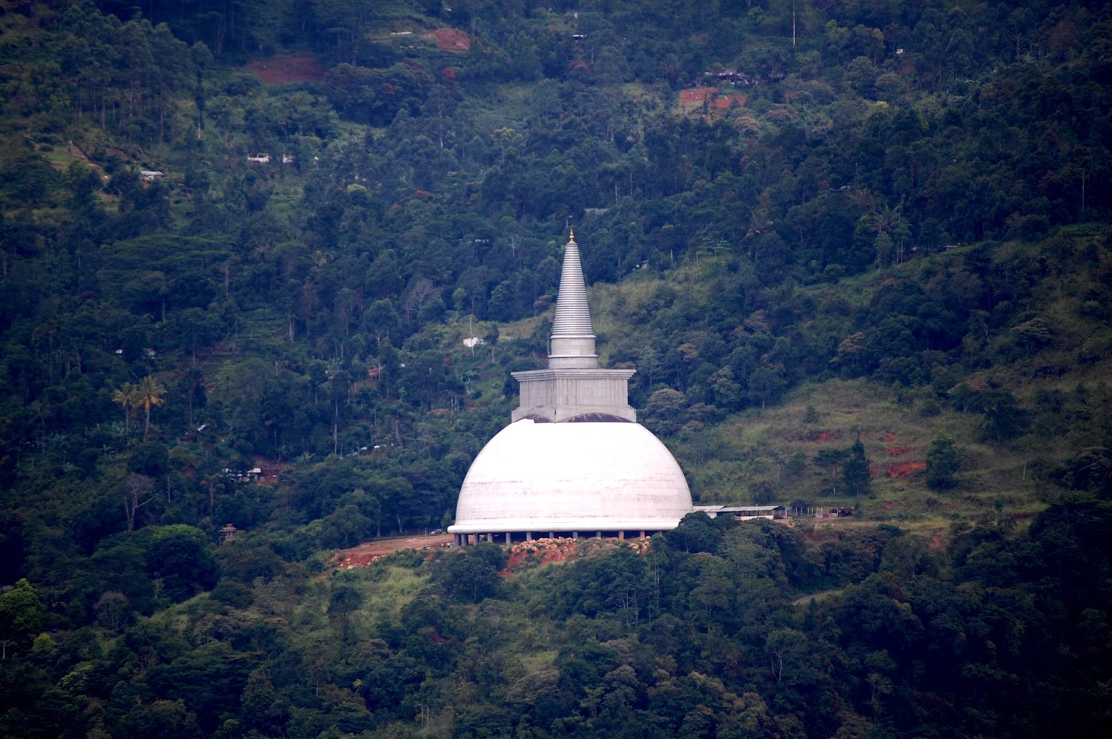 |
| Pic - Uditha Wijesena Mahaveli Seya [Stupa] in its finishing stages |
The construction of this Stupa which was started on March 20th 1983 was also stalled with his
demise. However it was constructed to a complete and declared open on 20th June 2016 after 33 years. It’s a pity to think of such a
strong character as Gamini Dissanayake to have ruined his illustrious political
carrier and his aspiration to lead the country in such a tragic way.
No doubt the religious minded
and the one engulfed in superstition would prefer to highlight his sudden fall
to the spells and an omen cast upon him for smudging the once beautiful valley named Kotmale that was also known 'The Sunset Valley'…
Wow, sir, gorgeously written
ReplyDeletethanks for the pic credit.
I think we all should be aware of the plus and minuses of the projects we go through.Every major project has an impact on both society and culture while uplifting the living standards of the people. Specially for countries like Sri Lanka.
Despite all this destruction Sri Lanka still have power cuts . But these invaluable assets of Buddhist culture should have not been touched . You can build many resevoyers but these assets can never be replaced .
ReplyDelete